Aim: To locate the potential site based on the given condition.
Question: An Organization is planning to establish its functional unites for which they are considering a prevailing bush land and inhibited area. The task is to select a specific site that meets the following requirements:
- The site should not be inhibited area.
- The site must be 500m distance from the inhibited area.
- The prevailing building rule prohibits any construction within 150 m of streams.
- The site must be within 500 m distance from existing road.
- The site shouls have the soil type with bearing capacity greater than 400 K N/m2
- The site must not be within 100 m distance from the existing roads.
The task here is to locate the potential site that meets these requirements.
MATERIAL USED
ArcMap 10.2
PROCEDURE
- Open Arcmap 10.2 →click blank template→hit ok
- To add image : Add data →locate the image on drive → hit ok

Following procedure are done for each requirements.

- To select bush land. : Arc toolbox→analysis tools → extract →select

Input – ”landuse”
Output – “bushland”
SQL → LU TYPE( double click) – “LU TYPE=” →get unique value→bushland →ok

If it is not appeared, then right click on the ‘landuse’ at the ‘layer’ →properties → symbology →
add all values → apply → ok

Q1) To select inhibited area
Arc toolbox→analysis tools → extract → select
Input – “landuse”
Output – “ inhibited”
SQL → LU TYPE ( Double Click) – “LU TYPE=” →get unique value →inibited area → ok

Q2) a. To widen the inhibited area
Proximity→ buffer
Input – inhibited
Output – inhibited_area500
Distance – 500m


b. to extract inhibited_area500 from bush land.
Arc toolbox – analysis tools – extract – clip
Input – bushland
Clip Feature – inhibited500
Output – opl

Q3) a. To widening streams
Proximity → Buffer
Input → stream
Output → stream 150
Distance → 150 m

b. To erase overlapped stream150 area
Analysis → overlay → erase
Input – output1
Erase feature – stream150
Output – output2

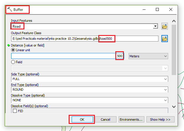
Q4) a. To widening the road
Proximity → buffer
Input – road
Output – road500
Distance – 500m
b. To extract the area within the 500 m
Arc toolbox → analysis tools → extract → clip
Input – output2
Clip features – road500
Output – output3

Q5) a. To select the site area which have soil bearing capacity 400 K N/m2
Right click on soil layer → open attribute table → check → 450 → gravel →soil type

Arc toolbox → analysis tools → extract → select
Input – “soil”
Output – gravel
SQL → SOIL TYPE (Double click) → “SOIL TYPE=” → get unique value → gravel → ok

b. to extract area within the gravel
Arc toolbox → analysis tools → extracts → clips
Input – output3
Clip features – gravel
Output – output4

Q6) a. To widening the roads upto 100m
Proximity – buffer
Input – road
Output – road100
Distance – 100 m

b. To erase the overlapped area
Analysis – overlay – erase
Input – output4
Erase feature – road100
Output – final_output

RESULTS


Practice Material Link:
No comments:
Post a Comment